Thomas Christensen | Project coordinator |

DESCRIPTION
E-navigation, Competences and Recruitment challenges, Vessel traffic data & Maritime planning, Dynamic Risk Management.
PROJECT SUMMARY
Increased traffic in the Baltic Sea is a result of the growing economic activity. Correspondingly, increased traffic is a determining factor for the growth of the region. Trade development has been suggested to be shifting more trade from land to sea, increasing the global fleet of oceangoing vessels and building larger vessels.
In the Baltic Sea, a Particularly Sensitive Sea Area, we have to be concerned with improving efficiency, safety and environmental sustainability as traffic increases. An efficient approach into maritime safety and efficient protection of the environment through accident prevention and mitigation is necessary. We need to raise public awareness for the impacts and opportunities that maritime affairs bring to both, the economy and the environment.
The EfficienSea Project represents a strong and viable partnership, consisting of organizations with considerable knowledge, experience and formal authority within the thematic fields of the Work Packages.
Some of the work will place strong emphasis on strategic aspects (e.g. e–Navigation in WP4), other parts focus on applications and policies of the BSR (e.g. Lisbon agenda through Capacity Building and Recruitment in WP3). Building on existing expertise and technology, the project’s development of new tools and systems is definitely innovative by nature (e.g. e-Navigation and Dynamic Risk Management).
Transferability within the BSR is a particular priority for the project. Activities are planned fully transferable. In some cases, transferability is challenged by regulatory and geographical contexts, e.g. in the field of maritime planning. Both the EU Commission and the Baltic Council will give priority to maritime spatial planning in the years to come and this project has the ambition of being valuable for National and European authorities.
The tasks and deliverables have been worked out in the spirit of transnationality, with the aim of facilitating implementation in the entire BSR after completion of the project. The tasks identified in this project generally have high priority in the organizations involved as they match their respective mandates. Thus, this project by nature represents added value to the partners and in turn to the BSR.
Some of the deliverables will shape future actions of the project partners. Others will serve as frame documents for investments in the private sector. Hence, Interreg funds will have multiple effects in the years to come.
The project vision is towards clean, safe and reliable maritime traffic in the BSR. The underlying principles of the overall project are efficiency, safety and sustainability framed by the Lisbon and Gothenburg agendas.
Information/data management o Effective and robust voice communication and data transfer o Systems and equipment o Ship reporting o Traffic monitoring; and/or o Training and familiarization
| Organisation |
|---|
Danish Maritime Safety Administration |
Swedish Maritime Administration |
Swedish Maritime Safety Inspectorate |
SSPA Sweden AB |
Chalmers University of Technology, Sweden |
innish Maritime Administration |
Helsinki University of Technology, Finland |
Kymenlaakso University of Applied Sciences, Finland |
Norwegian Coastal Administration |
The County Council of Moere and Romsdal, Norway |
Norwegian Centre of Expertise Maritime |
Estonian Maritime Administration |
Maritime Institute in Gdansk, Poland |
Maritime University of Szczecin, Poland |
National Institute of Telecommunications, Poland |
Gdynia Maritime University, Poland |
Maritime Office in Gdynia, Poland |
Details of the findings:
- Findings from the evaluation suggest that the intended route feature well serves its purpose.
It can also serve as a less ambiguous ground for route negotiations, even if this behavior was not intended from the start. Subjects were generally positive to the tool. But issues were raised as for instance on the cluttering of the chart in the VTS display and on that in very tight and time constrained collision situations none of the ships will have time to click intentions into the ECDIS. - Another concern raised by the VTS operator was the question of responsibility for the route exchange. As an example the VTS operator was contacted by one of the vessels asking him to send a suggested route to the other vessel to keep out of his way. As it is today the VTS is only entitled to give information services while the executive decisions on navigation remain the responsibility of a ship’s captain and the navigating crew. Sending routes from shore might eventually require to move some of this executive decision making power to shore to be able to avoid unnecessary negotiations in critical situations.
- Results from the simulation were promising and solutions for the problems encountered will have to be found until the next iteration of the route exchange service.
Statistics; No quantitative data was collected
User-experiences; etc. The exercise management was so happy with the prototype system that they moved their primary command and control interface from the paper chart to the ee-INS to monitor the drill.
The crew of the three units equipped with the test prototype was overall very positive.
In the debriefing that took place a couple of days later the ee-INS system and the ability to send and receive intended routes got appraisals from the exercise command and the participating crews that had come in contact with the system.
Details of the findings
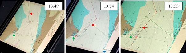
- Presentation of data: When the exercise started the OSC designated a search area to each unit. This search area was transmitted using VHF radio in spoken voice transmitting 4 coordinates containing longitude and latitude (the words “north” and “east” and two times six digits). These coordinates were then received onboard each unit and was written down on a piece of paper by the radio operator. This piece of paper was then handed to the navigation officer at the front of the bridge who started to program the ships ECDIS system. Clicking through different menus and finally entering the same 12 numbers the search area finally appeared on the ECDIS. On the observation video this process on one of the units, from start of the VHF transmission until the search area appeared on the ECDIS screen, took 14 minutes. The whole time the search polygon was present on the ee-INS screen, sent in the same time the VHF transmission started.
For a professional and trained crew this process had probably gone a lot faster, but using volunteer crews with limited time for training is the reality for many sea rescue services around the world and even with a trained crew the risk of misinterpreting a number transmitted in voice and in hand writing still remains. The transmission through the AIS binary messages on the ee-INS was produce by a graphical interface on the OSC ship and was instantly presented on the unit it was addressed to.
After the three test units had received their search polygons and programmed in their search pattern in the standard ECDIS of the ship, the navigator once again entered the search pattern in an approximate way on the ee-INS, right clicked and chose ”active route” in the menu. As the route was made active it was immediately broadcasted to all ships in the vicinity with an ee-INS and would be visible if the configuration “show intended routes” was activated. This way the OSC got immediate feedback of the intentions of the three units equipped with ee-INS.
- Statistics; No quantitative data was collected
- User-experiences; etc. The exercise management was so happy with the prototype system that they moved their primary command and control interface from the paper chart to the ee-INS to monitor the drill.
- The crew of the three units equipped with the test prototype was overall very positive.
- In the debriefing that took place a couple of days later the ee-INS system and the ability to send and receive intended routes got appraisals from the exercise command and the participating crews that had come in contact with the system.
- Method: System simulation (Lützhöft et al., 2010) Observation and interviews
- Validity: high, high context simulator tests
- Reliability: Qualitative data from real users
- The type of user group/s involved in the test
- Ship-board users (captains and pilots) and shore-based users (VTS operators)
- Details of persons involved in testbed
- Number: 7 vessels with a bridge crew of 2 each (captains, cadets and pilots)
- Background: 4 professional captains 5 fourth year cadets and 2 pilots
- Demographics etc. Mixed ages and gender
- Procedure used in the test
- User requirements: Three focus interviews with captains, pilots and VTS operators during the design phase of the system
- Technical solutions used: A prototype ECDIS (the e-Navigation Prototype Display –EPD) developed by the Danish Maritime Authority was used as a laboratory platform.
- Standards: An extended AIS protocol was used
- SOPs; etc.: A baseline simulation was first done 9 May 2010 with a standard scenario based on regular traffic in the Sound (two 3 hrs. simulations: “normal” and “busy” conditions)
he tested system was very successful and the prototype system is now used by the Danish Marine Home Guard.
Lessons learnt;
Future plans;
- The system is now developed to a tool that can be used also for oil spill and other types of operations. This tool named Vessel Operations Coordination Tool (VOCT) will be tested in the ACCSEAS project 2012-2015.
TESTBED 1: INTENDED AND SUGGESTED ROUTES
SUMMARY
Misunderstanding each other’s intentions is one of the most common causes of shipping accidents. By sending out a number of waypoints ahead and displaying them on the Electronic Chart Display and Information System (ECDIS) a ship’s intentions would be clearly visible for other ships. Displaying ships’ intentions would be a major change compared to navigation today. It could be very beneficial but it could also have unintended consequences. This testbed investigated the technical solutions by the Danich Maritime Authority as well as reported on findings from an study where we was looking for unintended consequences of change using system simulation at the full mission bridge simulators at Chalmers University of Technology in Sweden.
During the simulation an unanticipated behavior was observed. Bridge crews started to click and drag waypoints too negotiate crossing situations ahead of time. The behavior could be compared to agreeing over the VHF. However further research is needed to evaluate this new behavior and how it aligns to COLREGS.
Several times every year Sound VTS (in the sound between Sweden and Denmark) has to call up vessels heading for shallow areas in the narrow passage. The interception is often made in the last minute using voice call on VHF. Being able to see ships intended routes a number of waypoints ahead would make it possible to interact at an earlier stage. Being able to send a route advice graphically direct to the ships ECDIS system might mitigate ambiguity and misunderstandings due to language problems or problems of naming reference points.
The system was tested at the full mission bridge simulators at Chalmers University of Technology in Sweden and later in full context in a variation intended for SAR users (see the next section “Testbed 2: SAR Tool”).
TESTED SERVICE
Transmission of intended routes through ship’s transponder
Presentation of other ships intended route on prototype ECDIS display
Broadcast of suggested routes from shore (e.g. VTS) to a specific ship
Display of suggested route on the ship’s prototype ECDIS
Testbed location: Simulator trial, he full mission bridge simulators at Chalmers University of Technology in Sweden.
Contact persons:
- Technical development: Ole Bakman Borup, Danish Maritime Authority, OBO@dma.dk
- User evaluation: Thomas Porathe, Maritime Human Factors, Chalmers, thomas.porathe@chalmers.se
TESTBED 2: SAR TOOL
[[{"fid":"641","view_mode":"default","fields":{"format":"default","alignment":"","field_file_image_alt_text[und][0][value]":false,"field_file_image_title_text[und][0][value]":false},"type":"media","field_deltas":{"3":{"format":"default","alignment":"","field_file_image_alt_text[und][0][value]":false,"field_file_image_title_text[und][0][value]":false}},"link_text":null,"attributes":{"height":455,"width":736,"class":"media-element file-default","data-delta":"3"}}]]
TESTED SERVICES
Transmission of search areas to Search and Rescue Units (SRU)
Presentation of search areas on SRU display
Broadcast of planned search patterns from SRU
AIS SART usability and presentation on SRU display
TERMS OF REFERENCE FOR THE TESTBED AND BACKGROUND
The type of user group/s involved in the test
- SAR users
Details of e-navigation gap/s considered in the test (for instance as outlined in NAV 58/WP.6):
- Information/data management
- Effective and robust voice communication and data transfer
- Systems and equipment
- Ship reporting; and
- Traffic monitoring;
- Information about similar / relevant testbeds (if any)
- Tests with an iterated system will continue in the ACCSEAS project 2012-2015